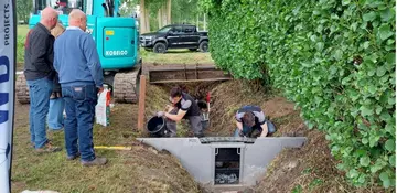
BE, Sint-Gillis-Waas Weir Project
Map
Privacy notice for OpenStreetMap
When using the interactive OpenStreetMap, personal data, in particular your IP address, is transmitted to the OpenStreetMap server. This is done in order to display the map data and provide the service.
BE, Sint-Gillis-Waas Weir Project
Best practice profile
Good practice
Climate-resilient agriculture by using weirs – Sint-Gillis-Waas Weir Project
Country
Belgium
Biogeographical Region
Atlantic
Region
Sint-Gillis-Waas, East Flanders, Belgium
Landscape/ Eco system type / protected area
Agricultural landscape; polder-type lowland with field ditches and drainage canals in Sint-Gillis-Waas
Agriculture Use
Arable land (maize, vegetables), grassland, fruit orchards (pears). Intensive farming in a climatestressed landscape prone to both drought and flooding