IR, Burren
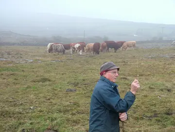
© Brandon Dunford
Map
Privacy notice for OpenStreetMap
When using the interactive OpenStreetMap, personal data, in particular your IP address, is transmitted to the OpenStreetMap server. This is done in order to display the map data and provide the service.
IR, Burren
Best practice profile
Good practice
Result-based Agri-Environmental Scheme “Burren Programme”
Country
Ireland
Biogeographical Region
Atlantic - karst
Region
West Ireland – County Clare
Landscape/ Eco system type / protected area
- Parts of two counties (Clare and Galway along Ireland’s mid-western coast. A small area of the Burren is protected as a National Park, but the rest is privately owned. Its boundaries encompass five Special Areas of Conservation within the Natura 2000 Network, covering a total of 47,000 ha.
- In addition to the limestone pavement, major landscape types, providing the habitats for the flora and fauna, include limestone heath, dry calcareous grasslands, calcareous (calcifying or petrifying) springs, the intermittent water bodies called turloughs, bogs, Cladium fens, lakes, wet grasslands, scrub and light woodland, and neutral, and farm-improved, grasslands.
Agriculture Use
- Cattle, sheep and goats would historically have been the type of animals kept on the area of the Burren.
- Today, most Burren farmers keep ‘suckler cows’, with an average herd size of 30-40 cows.
- In the Burren uplands, animals are moved to the hill pastures in winter, so called “winterage”. Calving takes place around February–April, toward the end of the winter period.
- These cattle are kept on fertile lowland grasslands during summer before the calves are weaned, fattened and sold (usually at the local mart), with the in-calf mothers heading back onto the Burren hills in October onwards for another winter.
- Some silage or hay may be saved during summer to be used as supplementary winter feeding (on the winterage or inside ‘slatted’ houses).