
LT, Baisogala
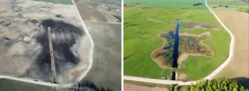
© Nerijus Zableckis
Map
Privacy notice for OpenStreetMap
When using the interactive OpenStreetMap, personal data, in particular your IP address, is transmitted to the OpenStreetMap server. This is done in order to display the map data and provide the service.
LT, Baisogala
Best practice profile
Good practice
Demonstration restoration of a peatland (fen) in Baisogala. Reshaping intensively used agricultural land to meet climate change mitigation
Country
Lithuania
Biogeographical Region
Boreal
Region
Radviliškis district municipality
Landscape/ Eco system type / protected area
Former fen (peatland), drained and used as perennial grasslands for haymaking and grazing (pastureland).
Agriculture Use
Before rewetting, the drained peatland and surrounding areas on mineral soils were used as intensively managed perennial grasslands for fodder production and grazing. Currently, the rewetted area is used as wet grassland (dominated by Phalaris arundinacea) for fodder production.